Expo 2030 Riyadh: Will the Investment Outlast the Event?
A city-wide spatial analysis of Riyadh's road network raises planning questions for the Expo 2030 legacy district, and the window to address them is narrowing.
Foreword
Watching the city transform at the speed it has over the past decade, new metro lines, new districts, new ambitions rising alongside everything being built, I kept returning to a question: how can these investments live longer and merge with the city's daily narrative, not only its eventful one?As a Saudi woman born and raised in Riyadh, it is an honour to witness this journey. I conducted a spatial analysis using a city-wide model I built to begin answering that question for Expo 2030, and as an experience strategist, I added the lens of citizen and visitor journey mapping: the logic of how a citizen or visitor actually experiences a place, where spatial analysis meets the framing of lived experience.
Saudi Arabia has allocated a budget of $7.8 billion to host Expo 2030 Riyadh [1], with the project projected to contribute almost $70 billion to Saudi GDP and generate approximately 171,000 direct and indirect jobs [2]. The event itself, 40 million visits, 197 countries, six months of global attention on Al Narjis, will almost certainly succeed. The Metro will run. The pavilions will fill. The world will watch.
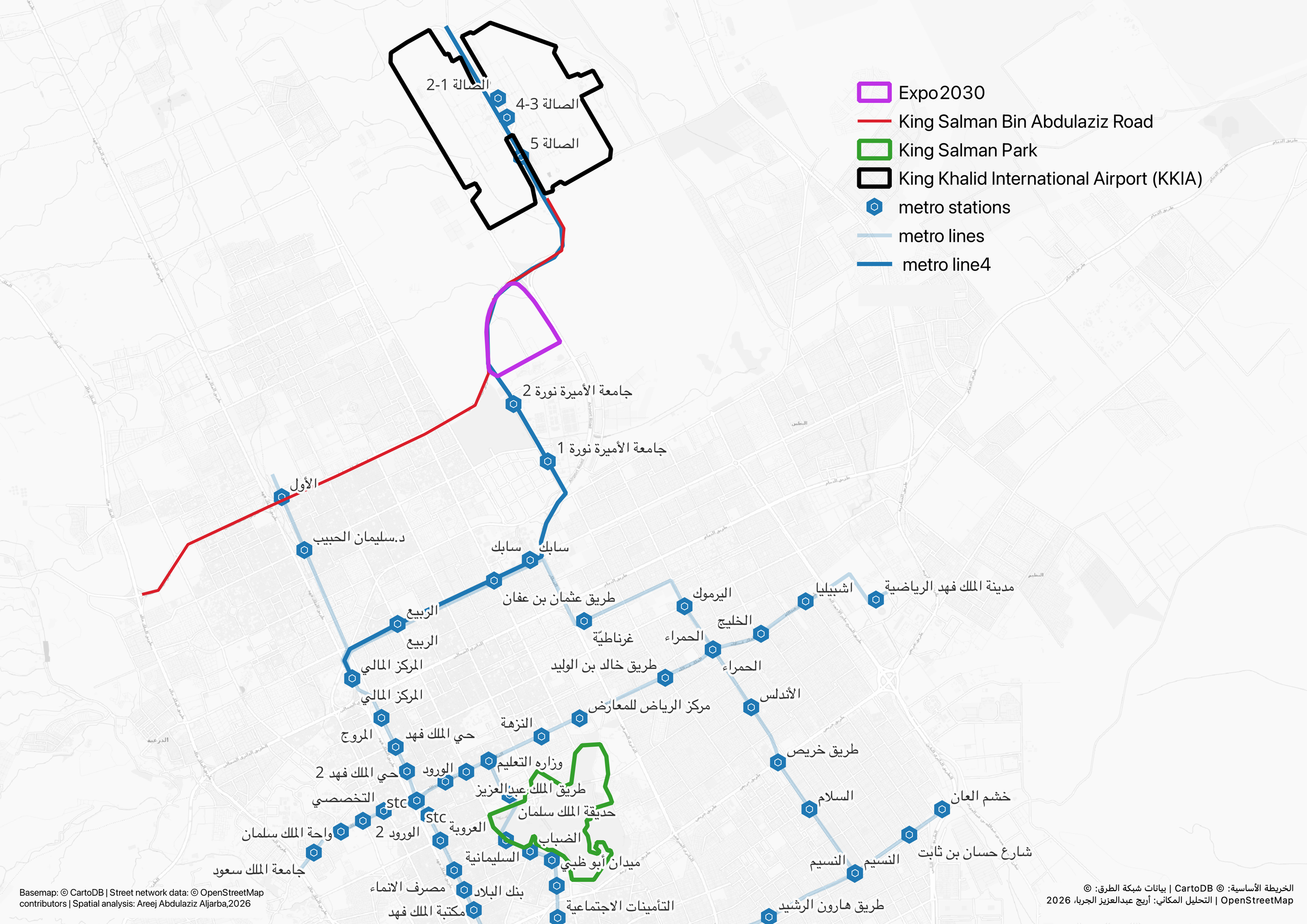
The Expo 2030 site in Al Narjis district, north Riyadh. Metro Line 4 runs along the site's eastern edge, connecting it to King Khalid International Airport to the north and the city centre to the south. King Salman Park, the city's major green infrastructure investment, sits approximately 15 kilometres south of the site.
The above map can be explored across multiple layers, from land use and demographics to traffic volumes and spatial connectivity, allowing a fuller picture of the site and the city fabric surrounding it to emerge.
The harder question is what happens on 1 April 2031, the morning after the Expo closes. That question has a data-driven answer. And the answer should be informing planning decisions right now, before construction is complete.
The Ambition Is Right. The Conditions Still Need Attention.
The Expo 2030 Riyadh Company (ERC), established by the Public Investment Fund, plans to transform the gated Expo area after the event into a permanent global village, a multicultural hub for retail, food and beverage, surrounded by an international residential community [2]. Following the event, the site will transition into what ERC describes as a district dedicated to innovation, knowledge exchange, cultural engagement, and community-driven urban experiences [3].
This is precisely the right ambition. World Expo sites that revert to empty pavilions after closing day represent one of the most well-documented failure patterns in large-scale event urbanism.
But transforming an event site into a living district requires two things that an Expo alone cannot provide:
a street network that makes the place easy to reach naturally, and a citizen and visitor experience that makes people want to come back when there is no global event pulling them.
Analysis of both dimensions raises questions that carry direct implications for the planning decisions still ahead.
What the Street Network Is Saying
A city-wide spatial analysis of Riyadh's road network makes it possible to measure, for any location, two things that shape whether a place can sustain itself as a permanent destination.
The first is ease of reach. Not merely whether roads connect to a place, but how naturally the city's entire road layout draws people toward it. Places that score well on this measure tend to become self-sustaining economic destinations, people flow toward them almost without deciding to. Places that score poorly tend to require a constant anchor: an event, a mandate, a government programme. Remove the anchor, and footfall thins.
The second is natural through-movement. Some roads carry people because they lie on the most direct route between many other places. These roads generate what planners call passive activation, the coffee shops, the chance encounters, the ground-floor retail that make a district feel alive on an ordinary weekday. Other roads are bypassed by the city's natural flows. You reach them only on purpose.
The analysis measures both conditions for every road segment in Riyadh simultaneously, producing a picture of where the city's movement naturally concentrates, and where it does not.
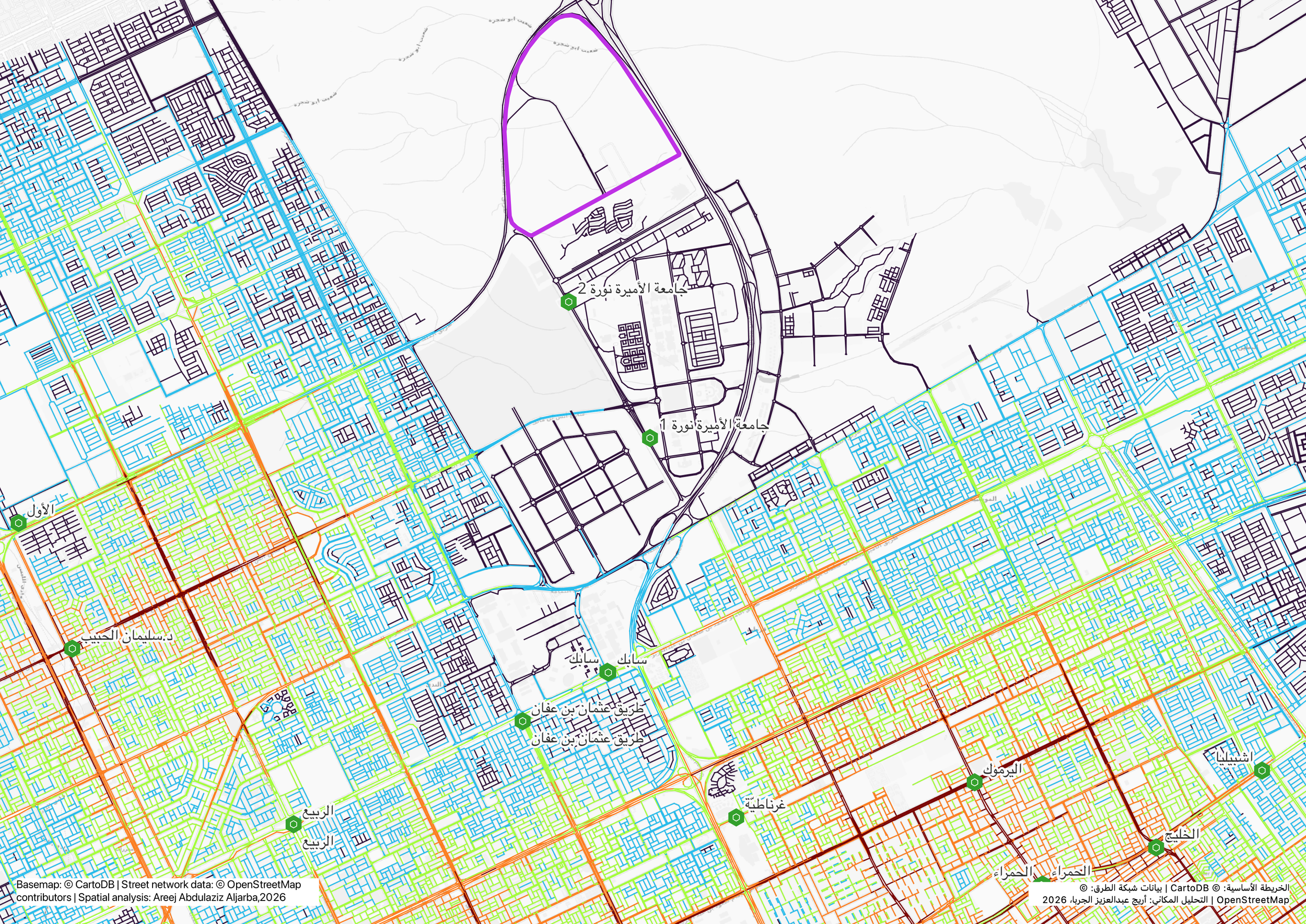
Street-level spatial accessibility across Riyadh at neighbourhood scale. Warmer colours indicate streets that are more naturally accessible from across the city. The Expo 2030 site sits at the edge of the city's accessible core, in a zone where accessibility values fall below the city average.
Applied to the Expo 2030 site in Al Narjis, the picture that emerges has two parts. At the broadest, city-wide scale, examining how well roads connect across the whole metropolitan area, the site is adequately positioned. Major arterials reach it. The Metro can serve it. This is the scale that explains why the event itself will function: enough of the city points toward Al Narjis for 40 million event visits to be viable.At city-wide scale, the Expo site sits at approximately the 47th percentile of the full Riyadh network, broadly in line with the city average.
But at the scales that determine whether a district sustains organic activity after an anchor event, the neighbourhood, the local street, the walking distance from a Metro exit to a cafe, preliminary analysis suggests the site is considerably less well-embedded in Riyadh's movement network.
At pedestrian scale, the streets in and around the site carry roughly 40 percent less natural movement potential than the city average, placing the zone in the lower third of Riyadh's full road network.
At neighbourhood scale, the pattern persists: the district-level street fabric surrounding the precinct is similarly weakly embedded relative to established activity zones elsewhere in the city.
The pattern that emerges is consistent across scales: major arterials pass near the Expo site but tend to bypass it rather than run through it. Visitors must leave the arterial network to reach the gates. The site, in its current configuration, is a destination you travel to with intent, not a place the city's geometry draws you toward naturally.
For the six-month event, this presents no significant challenge. For the permanent district, it is the central planning question.
What the Spatial Data Predicts About the Citizen and Visitor Experience
Network analysis tells us where people are likely to go. It does not, on its own, tell us what they will experience when they get there, or whether they will choose to come back.
These are different questions, and they require a different lens. A citizen or visitor at the Expo 2030 site does not experience a connectivity value. They experience a sequence of moments: stepping off the Metro, trying to orient themselves, finding somewhere to sit, deciding whether the walk to the next pavilion is worth it, choosing where to have lunch, leaving with a feeling they either want to repeat or quietly shelve. Each of those moments has a spatial condition underneath it. And spatial analysis can predict, in advance, whether that condition will support or undermine the decision being made.
This is the bridge between network data and lived experience. For the Expo 2030 legacy district, it is where the most consequential planning questions live.

Six stages shape every citizen and visitor's experience of the Expo 2030 site. At each stage, spatial configuration plays a role that programme, content, and marketing cannot fully replace. The analysis examines where that configuration supports the experience and where it does not.
A citizen or visitor's journey through the Expo site unfolds across six stages. At each stage, spatial configuration plays a role that programme, content, and marketing cannot fully replace.
Arrive: the first spatial test
Orient: the wayfinding moment
Engage: movement versus encounter
Dwell: time, comfort, and the unplanned discovery
Spend: where commercial activation succeeds or thins out
Return: the decision that determines legacy
This framework is not fixed to a single question. The spatial and experiential conditions at each stage can be analysed and calibrated to the specific priorities of the legacy district, whether that is retail performance, cultural programming, residential viability, or the business model of the global village as a whole. What follows examines the stage where the spatial data speaks most directly.
Arrive
Metro Line 4 will be the primary arrival mode for most visitors, connecting directly to the site and designed to handle the projected visitor volumes. That is the easy part. The harder part begins the moment they step out of the station.
The critical question at the arrival stage is not transport capacity. It is what happens in the space between the Metro exit and the Expo gate, a sequence of streets that a citizen or visitor must navigate on foot, in Riyadh's climate, before they have seen a single pavilion or been rewarded for the journey.
The analysis measures, for each road segment in the city, how often it lies on the natural routes between all other places, a metric that consistently predicts observed pedestrian activity levels. In the Al Narjis area, the streets between the station and the Expo gates score low on this measure relative to the wider city. The segments in this zone place them among the lower-scoring portions of the city's pedestrian-scale network, carrying significantly less natural movement than most of Riyadh's residential and commercial areas.
They are not on the routes people would naturally use to travel between other destinations. Nobody passes through this area incidentally. The streets exist, but they are not animated by the background activity, other pedestrians, open frontages, visible destinations, that makes an arrival sequence feel safe, legible, and worth continuing.
This matters because arrival is not a neutral transit phase. It is the moment when a visitor's accumulated expectation meets physical reality for the first time. Research into citizen and visitor behaviour at large urban destinations consistently shows that the arrival sequence primes the entire experience that follows. A disorienting, inactive arrival environment depletes the goodwill a visitor brought with them. They arrive slightly diminished, less patient, less curious, less forgiving of what they encounter next.
During the event, this cost is manageable. Purpose-built signage, staff at key decision points, and the sheer pull of the Expo itself can all compensate. Visitors absorb friction because they came with strong intent.
After 2031, the calculation is completely different. A resident of Al Narjis deciding whether to visit the legacy district on a Thursday evening, or a family choosing between the Expo site and a well-connected alternative elsewhere in northern Riyadh, will make that decision partly on the basis of what arriving there feels and looks like. A street network that does not generate natural movement does not generate the ambient vitality that makes arrival feel like an invitation rather than a commitment.
The arrival experience is, in this sense, a preview of everything the legacy district will need to be.
The remaining five stages, orientation, engagement, dwell, spend, and the return decision, each carry their own spatial conditions and their own considerations. This framework can be extended and tailored to the specific strategic questions of the Expo legacy district: which zones generate dwell, where commercial activation is spatially supported, and what the return visit decision depends on. A full citizen and visitor journey analysis calibrated to the Expo 2030 site is available as a structured briefing.
Making the Invisible Visible
Every major urban investment has layers. The masterplan layer covers land use, building massing, and programme. The transport layer covers modal capacity, station locations, and road hierarchy. Between them sits a third layer that rarely belongs clearly to any single planning team: the spatial and experiential layer, the specific configuration of streets, the quality of connections between transport and destination, and the conditions that shape how a place feels to move through, arrive at, and decide to return to.
This third layer is where spatial analysis and lived experience meet. The question shifts from whether people can get there to what happens when they do, and whether what happens is compelling enough to bring them back without the pull of a global event.
What this analysis contributes to the Expo 2030 masterplan is precisely this lens: a way of reading spatial conditions and connecting them to the experience logic and business model of the legacy district. Where does the street network support dwell time and spend? Where does it thin out commercial activation? Where does the arrival sequence invite or exhaust? These are revenue questions, asset value questions, and legacy questions, and they have spatial answers that can be mapped, benchmarked, and acted upon before construction commits.
This approach can be calibrated to the specific priorities of the legacy district, whether the focus is retail performance, cultural programming, residential viability, or a combination. The analysis adapts to what the Expo legacy district most needs to understand about itself.
What it offers, at this moment, is visibility into a layer that is still adjustable, before the decisions that shape it become expensive to reverse.
The Window Is 2025 - 2027
The specific question this analysis puts on the table is not whether to proceed with Expo 2030. It is whether the street network surrounding the site can be brought into a configuration that supports long-term urban life, and whether that work happens now, at design stage, or later, when it has become remediation.
Major road layout decisions for the Al Narjis area need to be made within the next two to three years. After that, they become embedded in construction sequencing, utility placement, and land parcelling arrangements that are significantly more expensive to revisit.
The spatial analysis identifies where the highest-impact interventions would focus. Those findings are the subject of the structured briefing available on request.
Expo 2030 Riyadh is projected to contribute almost $70 billion to Saudi GDP [2]. The legacy, the permanent district, the long-term return on that investment, the transformation of Al Narjis into a place Riyadh is proud of in 2040 and 2050, depends equally on the quality of the spatial foundations. The window is open. It will not remain so for long.
AUTHOR
Areej Abdulaziz Aljarba
Experience Strategist and Spatial Intelligence Advisor
Experience strategist and spatial analyst with 8+ years working at the intersection of how places are configured and how people actually experience them. This analysis draws on a city-wide spatial model of Riyadh's road network built using Angular Segment Analysis methodology developed at UCL, combined with citizen and visitor journey mapping applied across built environments, public institutions, and urban investment contexts.
A structured briefing on the Expo 2030 site, including full citizen and visitor journey analysis and spatial intervention scenarios, is available on request.
References
[1] Minister of Investment Eng. Khalid bin Abdulaziz Al-Falih, BIE 172nd General Assembly, Paris, June 21, 2023. Royal Commission for Riyadh City (RCRC):
https://www.rcrc.gov.sa/en/news/saudi-arabia-allocates-7-8-billion-for-riyadh-expo-2030
[2] Public Investment Fund (PIF), "PIF launches new company to deliver Expo 2030 Riyadh," June 19, 2025:
[3] Love That Design, "Expo 2030 Riyadh's Masterplan: 195+ Countries, 29 International Organisations and 1 Common Goal," November 2025: